Log in
All resources
Create a design
11,660 Free Images of Old Map
bibliothèque nationale de france
paper
maps in the library of congress
baroque
matthäus merian
maps by willem and johannes blaeu
engravings of topographia austriacarum
austria in art by matthäus merian
details of old maps
british museum
details of old maps
la virginea pars
old maps of siena
duchy of castro
eran laor cartographic collection
alexis-hubert jaillot
le neptune francois
charles pène 8th
the history of barbados; comprising a geographical and statistical description of the island (1848) by robert h. schombourgk
old maps of barbados
old maps of auvergne
1660s maps of france
naturalism,symbolism
maps of stockholm
maps in the library of congress
1863 maps of the united states
the british monarchy (1743)
maps in the british museum
mauritshuis in the 17th century
dutch baroque architecture
details of old maps
la virginea pars
in the volcanic eifel. a holiday ramble (1896)
old maps of eifel
old maps of switzerland
maps from gallica
braun/hogenberg dreizehn orte
zürich in art
maps by daniel stoopendaal
biblical maps
birckenstein handgriffe (image set)
old maps of komárom
maps by johannes vingboons
old maps of kochi, kerala
historical
history
old maps of switzerland
maps from gallica
islands
maps
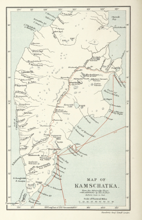
the cruise of the marchesa (1889)
kamchatka oblast
old maps of the peloponnese
maps of the peloponnese
maps by willem and johannes blaeu
old maps of gâtinais and sénonais
maps in the aguirra collection
negative photography
atlas des anciens plans de paris by imprimerie nationale, 1880 from bhvp
proletarian literature
rue louis majorelle (nancy)
école de nancy,art nouveau
maps in the library of congress
1744 maps
maps from university of amsterdam special collections
atlas der neederlanden
maps in the library of congress
1777 maps
atlas des anciens plans de paris by imprimerie nationale, 1880 from bhvp
dheulland map of paris
pages with maps
water
anthonis van den wijngaerde
historical images of lleida
russo-turkish war (1877–1878) in art
great eastern crisis (1875–78)
old maps of southeast asia
maps by isaak tirion
historical
history
petit atlas pittoresque des 48 quartiers de la ville de paris, bhvp
paris former 11e arrondissement
maps from university of amsterdam special collections
atlas der neederlanden
old maps of the whole peloponnese
guillaume sanson
eran laor cartographic collection
michel van lochom
description de l'universe
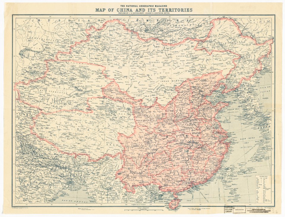
china in art
engravings of topographia austriacarum
baroque
illustrations from five weeks in a balloon by riou and montaut
old maps of africa
historisk atlas (stockholm, norstedt & söner, 1880)
old maps of the roman empire
maps from university of amsterdam special collections
atlas der neederlanden
maps in the library of congress
1770s maps showing history
parts of old maps of bremen
bremen in the 1600s
kurtze beschreibung von republick venedig
17th-century engravings of towns
maps from the earth and its inhabitants, vol. iv
ragstone
1831 maps of new york (state)
old maps of lower manhattan
old maps of the sinai peninsula
1840s maps of arabia
old maps of lazio
henry le roy
old maps of reims
ramparts of reims
town hall square (vilnius)
old maps of vilnius
old maps of the republic of genoa
maps by willem and johannes blaeu
17th-century maps of crete
old maps of candia
description de l'universe
old maps of valletta
the antiquities of athens (stuart&revett)
greek revival architecture
maps from the earth and its inhabitants, vol. xviii
old maps of lima
maps from the earth and its inhabitants, vol. xviii
1890s maps of peru
maps from the earth and its inhabitants, vol. xiv
maps of sumbawa
maps from the earth and its inhabitants, vol. iii
old maps of bonn
nuevo atlas o teatro mundo
old maps of the arctic
engravings of topographia austriacarum
baroque
engravings of topographia austriacarum
baroque
géographie générale; physique, politique et économique (1876)
old maps of the strait of gibraltar
maps from the earth and its inhabitants, vol. iv
amesbury
old maps of the holy land
thomas fuller (writer)
historical
history
nicolaus person
rhenish hesse
maps by hendrik hondius the younger
old maps of gâtinais and sénonais
patrimonium 2 (project)
realism
the cruise of the marchesa (1889)
old maps of kamchatka
old maps of north america
realism
maps by jakob van der schley
old maps of southeast asia
tower of babel in engravings
maps by nicolaes visscher i
arno river in florence in art
german renaissance,humanism
old maps of the balearic islands
catalan atlas
theodor fischer
thalkirchen
jean-baptiste-henri delahaye
philippe buache
old submaps of paris 5e arrondissement
turgot map of paris – derivative files
flandria illustrata
old maps of wervik
buda in the 17th century
baroque
the hague in the 1720s
old maps of the hague
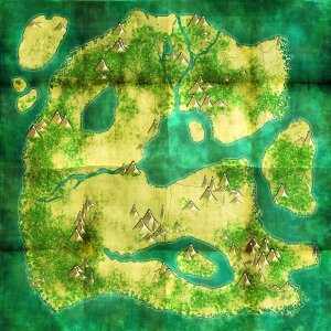
old maps of atlantis
island of california
suecia antiqua et hodierna, volume 3
history of visby
old maps of finnmark
1890s maps of norway
the history of barbados; comprising a geographical and statistical description of the island (1848) by robert h. schombourgk
old maps of barbados
description de l'universe
china in art
old maps of bourbonnais
1660s maps of france
maps by alexis-hubert jaillot
old maps of duchy of cleves
maps by alexis-hubert jaillot
old maps of the tyrol
our arctic province, alaska and the seal islands (1886)
old maps of alaska
old maps of viceroyalty of the caucasus
19th-century maps of crimea
engravings of topographia austriacarum
baroque
frans hogenberg
spanish armada
historical images of macau
asia noviter delineata
géographie générale; physique, politique et économique (1876)
old maps of the pyrenees
maps by pieter van der keere
old maps of friesland
maps by thomas starling
1842 maps
maps of the islands of greece by marco boschini (1658)
old maps of lesbos
9301 - 9400 of 11,660
Next page
/ 117


![Map of the polders of Old and New Roc-anje / A. Steyaart invenit; Heyman van Dyck fecit; I. Stemmer's sculpsit; I. Shutters fecit cum aqua forti, Romeyn de Hooghe, [1701]](https://cdn.creazilla.com/illustrations/10000510590/map-of-the-polders-of-old-and-new-roc-anje-a-steyaart-invenit-heyman-van-dyck-fecit-i-stemmers-sculpsit-i-shutters-fecit-cum-aqua-forti-romeyn-de-hooghe-1701-sm.webp)


![Map of the old new lands in West Voorn / I. Luiken fecit cum aqua forti; A. Steyaart invented; I. Stemmer's sculpsit, Romeyn de Hooghe, [1701]](https://cdn.creazilla.com/illustrations/10000299995/map-of-the-old-new-lands-in-west-voorn-i-luiken-fecit-cum-aqua-forti-a-steyaart-invented-i-stemmers-sculpsit-romeyn-de-hooghe-1701-md.jpg)


![Map of the Old Land of Diepen Dorst / I. Shutters fecit cum aqua forti; A. Steyaart invenit; I. Stemmers sculpt, Romeyn de Hooghe, [1701]](https://cdn.creazilla.com/illustrations/10001043124/map-of-the-old-land-of-diepen-dorst-i-shutters-fecit-cum-aqua-forti-a-steyaart-invenit-i-stemmers-sculpt-romeyn-de-hooghe-1701-sm.jpg)


![Sabinorum et Marsorum agri descriptio. 11; Typus utriusque Latii [...]. 8 / auctore Philippo Cluverio; H. Le Roy fecit, 1624](https://cdn.creazilla.com/illustrations/10001535937/sabinorum-et-marsorum-agri-descriptio-11-typus-utriusque-latii-8-auctore-philippo-cluverio-h-le-roy-fecit-1624-sm.webp)